GIS Projects & Initiatives
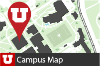 |
Campus Map The campus map was created through a partnership with University of Marketing and Communications and the FM GIS Team. The goal was to develop a campus map that was mobile, responsive, relevant, and accurate. The GIS team worked with various stakeholders around campus, developing the tools necessary to collect and maintain information that could be fed directly into the campus map, allowing information to stay accurate for its users. |
 |
Tree Tour FM GIS utilized ArcGIS Online tools to build a series of applications to assist the grounds crew in gathering location and health information for each tree on campus. A separate Tree Tour application was built from the data that that grounds crew collected and maintains. The tour has been designed to highlight just a handful of the many species and varieties of trees that can be found on campus. |
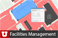 |
Facilities Management Web Application & Mapping The GIS Team works closely with Facilities Management Staff to collect information about various campus assets FM manages using ArcGIS Online tools (i.e. vegetation mapping, plow zones, irrigation data, district mapping). GIS Analysts use this data to develop informational maps and reports that will assist FM Staff in making business decisions. |
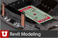 |
Revit 3-D Modeling FM BIM Specialists are currently working to put all of the University buildings into Revit in order to verify site plan and floor plan accuracy. Future work will include importing the Revit models into the GIS environment in order to create spatially accurate 3D models of campus. |
 |
UIT Web Applications The FM GIS Team works with a number of University Information Technology teams to create web applications that help these teams make better business decisions, identify certain IT issues, and identify areas of service improvement. |